The longest day
White light streams off dewy fields. Steam rises off the road’s shiny asphalt surface. The dawn feels soupy as we stroll north on SH6, coast on the left, farmland on the right. Already sweating we turn inland at the Wanganui Valley access road and clamber gratefully into the coolness of Tarpot Creek. After a bit of a wallow up the creek bed we identify the tired track, periodically resuscitated with tape by hunters. The ground trail of the hunted is easier to spot and sometimes we follow it instead. The forest starts off reasonably open and pliant by West Coast standards but we’re soon climbing and sidling a bush face to reach a side ridge. The side ridge connects to the ridge that leads to the Karnbach Range. By now we are negotiating barely penetrable scrub about the same time the gradient tilts to precipitous. Topping out on the crest of the Karnbach my arms are pumped, my hair is full of twigs, expletives are flowing as easily as a shortness of breath will allow and I’m wondering why I’m not jetting up the Landsborough. DJ points behind me to the Lord Range and the view of the snowy top of Mt Lambert and the Lambert Glacier at the edge of the Garden of Allah. We all grin recalling Xmas 2009.

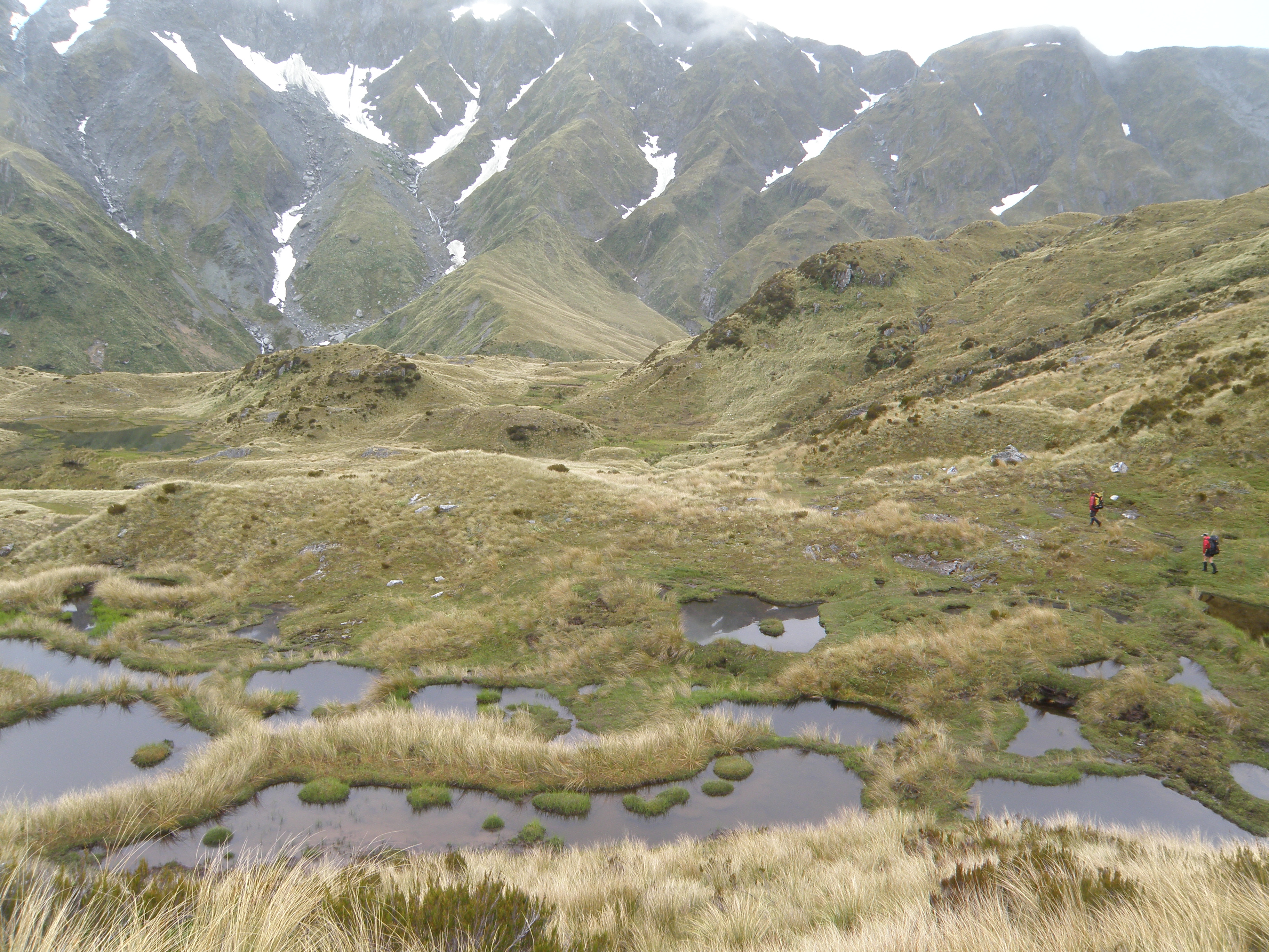
Can it get any hotter? We traverse the brown tussock tops and join another long, winding ridge. The Waitaha River glistens and snakes its way across the flats far below us. Hoards of chatting kea keep us company. We wave Mike on towards our destination and relax into the journey. The Karnbach Range merges with the Smythe as the afternoon merges with the evening. As the sun leaves the Range and the temperature drops to merely warm we spot the poles that mark the start of the descent to the Scamper Torrent River and its namesake 1971 vintage NZFS hut perched on a neighbouring hillock.

We share our accommodation with Emma who is part of the Permolat Group whose efforts at vegetation trimming, track marking and basic hut maintenance are instrumental in keeping the remote tracks of Westland and the associated hut network accessible for occasional visitors like ourselves. Emma’s 10 day trip is ending just as ours is beginning. Fortunately, given how few visitors this area gets, (less than 5 groups a year stay at most of the huts), Emma has been to some of the places we intended to go and is generous with route beta.
Xmas day
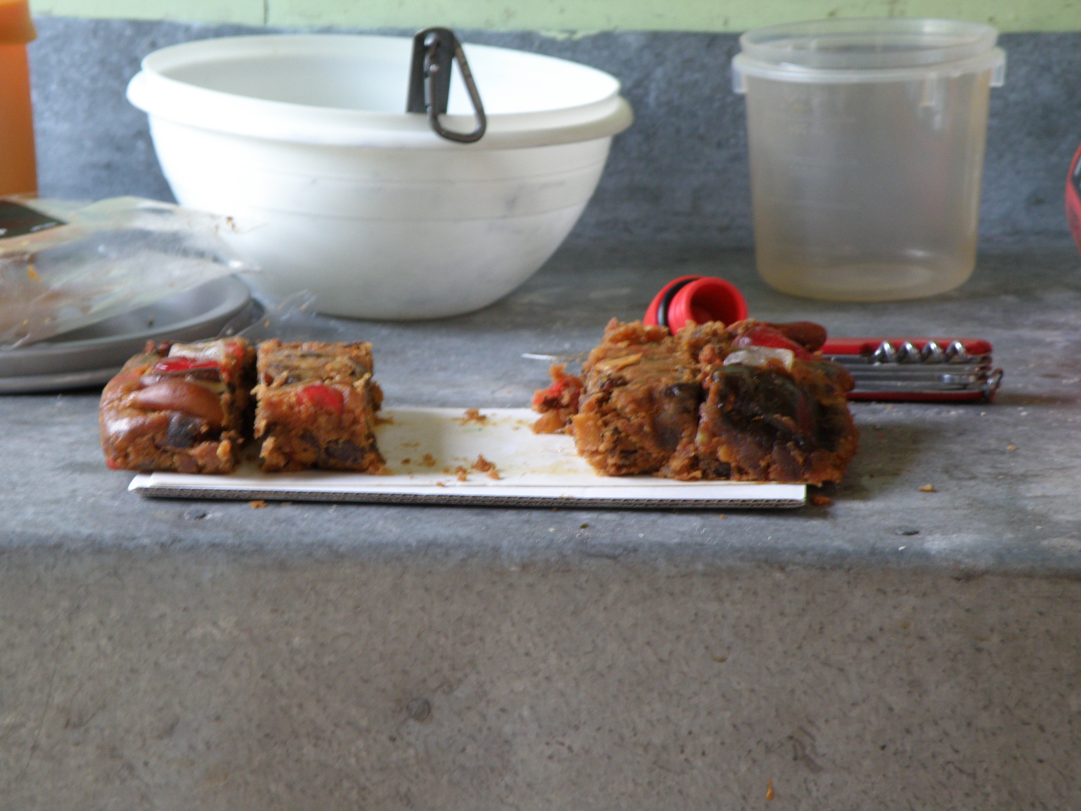
We are gifted a fantastic sparkling sunny day. Mike climbs 900m to summit Mt Durward. The rest of us relax first in the sun then in the shade of the hut. We read and munch on Xmas cake. As Xmas presents go, it doesn’t get much better than this.
Slip day
Watched over by bright sunshine we clamber back onto the Smyth Range and swing, slide and stumble our way down into the Waitaha catchment. At Kiwi Flat we meet a hunter who spent an unscheduled night out because of the slips. We reassure him then continue through the bush onto a terrace which we follow to the Headlong Spur turnoff. Lunch is consumed while eyeing the battered signs whose track times are scratched out or obscured behind permolat markers. These deliberate erasures together with the hunters’ misadventure are ominous signifiers of the fragility of the track system. Permolat volunteers re-marked the track in 2011 after windfall from a big storm in 2008 caused people to abandon the track but there has been further damage and Emma had no markers when she passed through. We took spare markers from Kiwi Flat Hut thinking we would do some marking but our full attention was required just to keep our footing and we spilt most of our markers.
From the turnoff the track sidles across the bush faces above the Waitaha Gorge. There are two large, active slips. Except for the requirement to tunnel through an enormous tangle of debris the first slip posed no major problems. We passed through a patch of regenerating hardwoods to the mother of all slips – long, steep and exposed. Emma’s advice was to go high. After much scouting without packs we settled on a line of ascent and carefully crossed the loose scree before bashing our way through bush on the other side. Where do we go now? Somehow DJ conjured up the track.
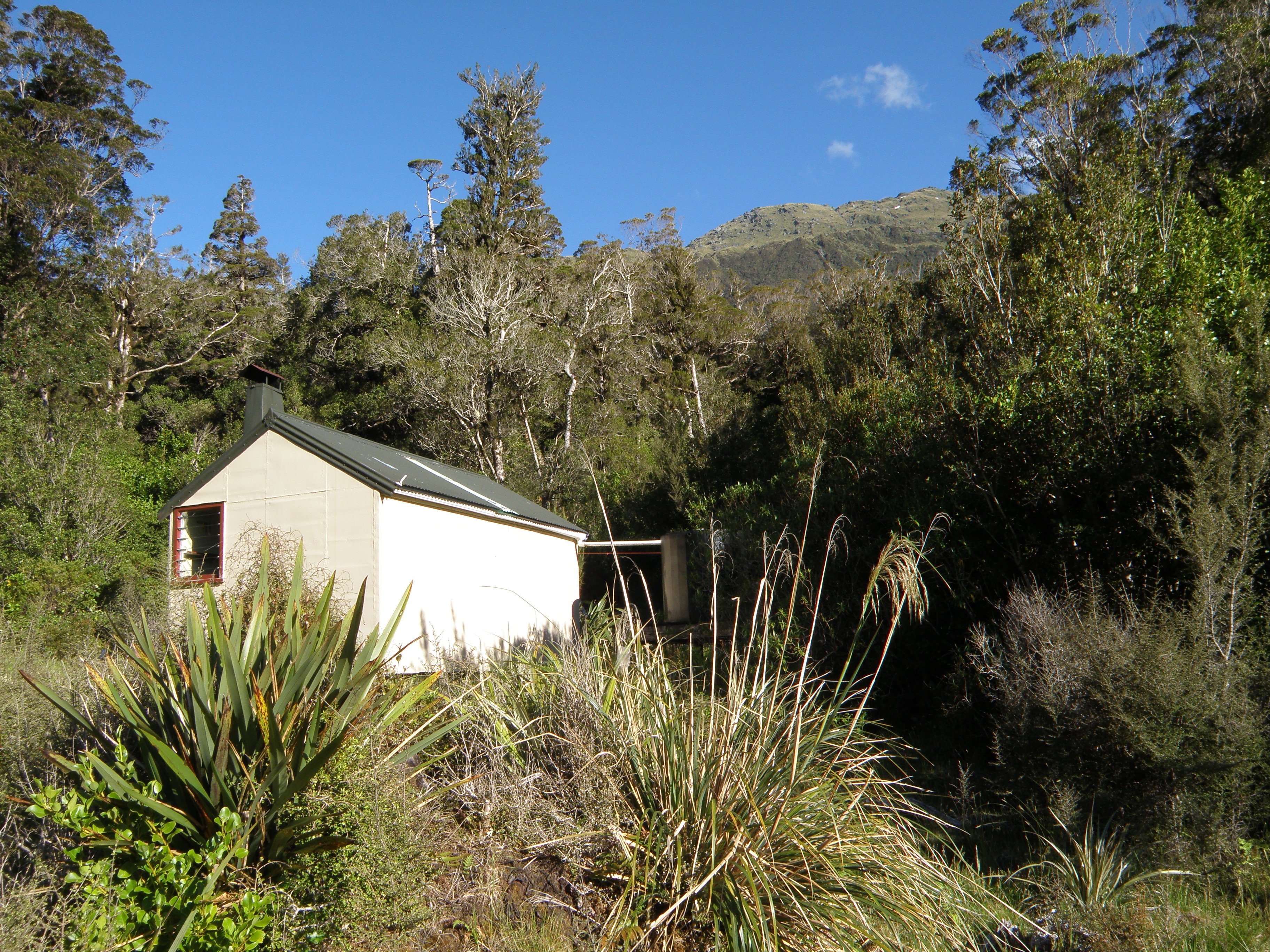
More monkey work followed, (swinging, sliding and stumbling) following a roller coaster sidle route till we emerged at the river. We were privileged to spy an adult Blue Duck/Whio with several chicks in tow. We undertook a short but intense bout of boulder hopping to get to the hut. I have no idea how Emma managed the route alone. I made full use of my companions for pushes and pulls and on several occasions simply removed my pack and passed it up and over boulders the size of national debts. Moonbeam hut, another 1971 vintage NZFS beauty, was a welcome sight.
Rocky Day
I knew following the Waitaha to County Hut would be a mentally challenging day for me because, like yesterday, the terrain had me recalling a particularly arduous section of Xmas trip up the Whataroa to Butler Junction just a few catchments south. At least we have sunshine I thought as we pushed our way through a mix of mature Halls Totara, Pahautea, Rata, Quintinia and Kamahi. After an initial bout of burrowing we reached the turn off to Top Waitaha. Here we continued on the County track cut by the Permolat volunteers ascending till we dropped into the County stream bed. We remained beside the stream except when jungle forays were necessary to avoid more national debt sized boulders. I suspect a colder summer would have enabled us to simply ford and re-ford the County – one down side of endless sunshine is that snowmelt kept the stream running high.
We hoped to lunch in the shade but the slopes of County Stream were just too rugged, prickly, dusty and steep for comfort so we climbed on river rocks where we had nice views of the foaming blue-grey water and surrounding hills. Arriving at the point where the track heads up to the hut we realised that crossing was infeasible. It took DJ and Mike the best part of an hour to select a suitable crossing spot. We retraced our steps over numerous large, slippery boulders that proved to be trickier to scale when tackled in reverse. The chosen crossing spot was excellent though and we waded across easily and this time Mike conjured up a route that hugged the stream bank and took us back to the main track without any need to scale the scrub covered cliffs on this side of the stream.
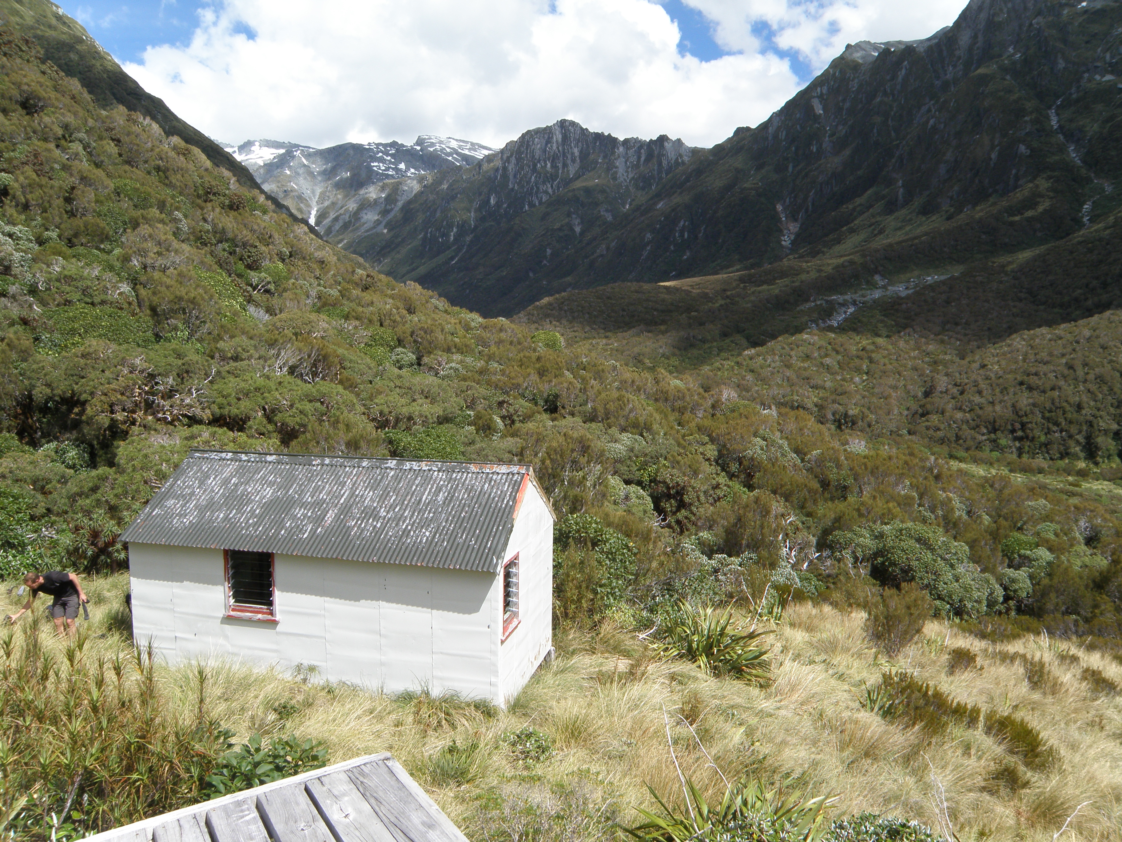
After hauling ourselves up the hill it was a relief to see County Hut, another NZFS 1970s vintage shelter complete with a cute exterior ledge for pack resting. Upstaging the hut was the flash helicopter pad which serves as an excellent viewing platform, stretching space and sunbathing spot. The two best things about County Hut were reading the hut book tales about flying in to climb Mt Evans and drifting off to sleep while being serenaded by a Bellbird/Korimako.
Over the Bloomfield Range
A grey sky hinted rain but after two days grovelling up the Waitaha we were desperate to get out of the valley and head up over the Bloomfield range to Top Waitaha Hut. Access to Mt Bloomfield can be gained via a steep rib between the two main branches of Bloomfield Creek. What appeared to be a Cinderella route was in fact an Ugly Sister. More hand over hand hauling up through speargrass dominated alpine scrub ensued. I regretted leaving my sunglasses in my pack as I took delivery of numerous free eye brow piercings. Cursing and bleeding we looked across to the snow slopes in the gully below us – definitely the superior route.
When tussock gave way to scree we paused to put on helmets as the route looked exposed, it was also quite windy and helmets are good for keeping sun hats on. We sidled below Artists Dome and climbed steadily up the crumbly rock onto snow. From Bloomfield Saddle (1900m) we had clear views down to a glacial lake till the cloud rolled in. Mike took over the step plugging to the summit of Mt Bloomfield (2106m). While the rain hadn’t showed up, at 2000+ metres visibility was patchy and anticipating a tricky descent we didn’t push our luck by lingering on top.
Phase one of the decent was easy, we followed snow slopes and stuck to the obvious ridge. Below the snow we relied on the GPS to clue us in on direction. We found a spot partially sheltered from the wind for lunch. We even spotted Top Waitaha hut far below us during a brief clearance. The clouds seemed keen to stick with us though now accompanied by drizzle.

Phase two of the decent required fortitude and patience, or in their absence, a bit of luck and chocolate. All decent routes looked impossibly steep close up. We needed a safe option – difficult to pick with only a few meters visibility. Although we had way points these did not take into consideration the nature of the terrain and we spent several hours testing various routes only to abandon them when they became too steep. Eventually we took a calculated gamble on a ridge that, due to its broken nature, was unrecognisable as such at our altitude. Once we slid a few hundred meters down saturated tussock the ridge took shape and we were able to confirm our route was relatively safe. Lots of painstaking down climbing later we dropped into the promised stream bed at 1300m and continued down secure in the knowledge that we were now where Moirs Guide recommended.

From the valley floor we were happy to swim through the thick, lumpy tussock to Top Waitaha Hut. This is another 1970’s NZFS beauty with the standard interior paint job – lime green walls and orange book shelves. Mike’s sleeping bag is a perfect match. This hut is lucky to get a single visitor per year which is a pity as the local hut weka is a charming, reformed kleptomaniac.

Glacier Lake day
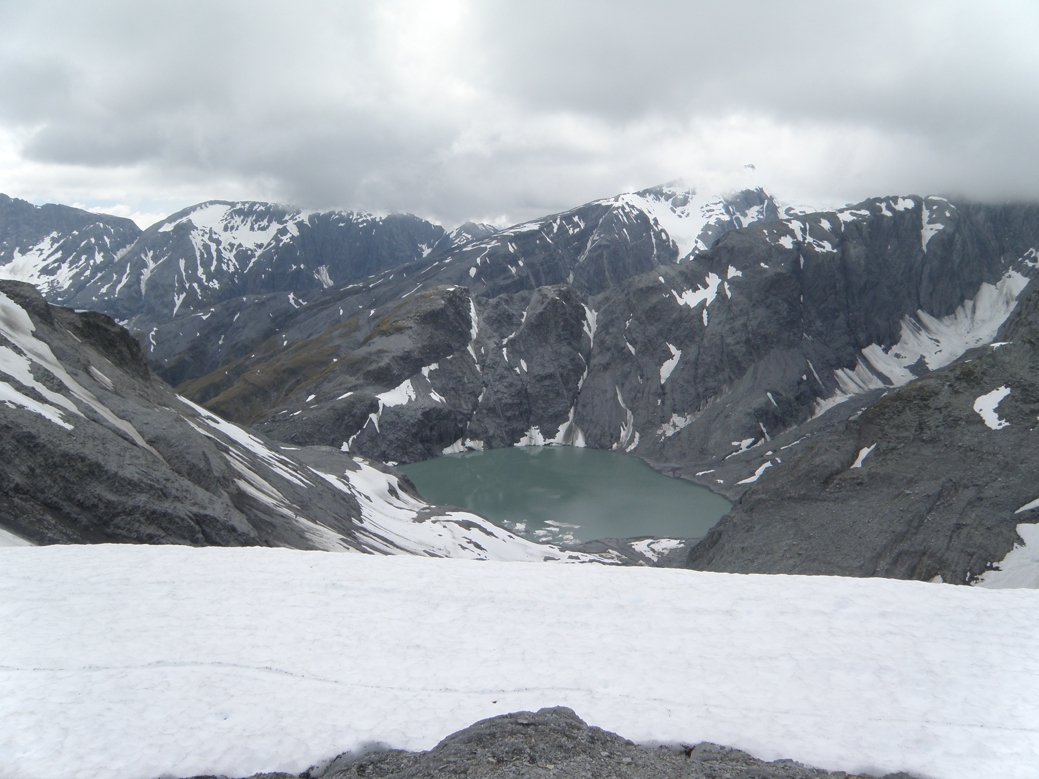
At dawn an earthquake shook the hut. While breakfasting we heard the thwamp of an avalanche. Undeterred we launched ourselves back into the slimy tussock and headed for the confluence of Reid and Stag creeks. From here climbed onto a flat tussock bench on the true left of Stag Creek where we wandered between numerous small tarns marvelling at how easy and pleasant the travel was compared with the mid Waitaha. The bench tapers out where the creek rises to meet it so we dropped into the creek and boulder hopped to the Ivory Lake Outlet Creek which is marked by a series of glorious, tiered waterfalls. Just past the waterfalls, studiously ignoring the exposure, we scaled a series of sloping ledges onto the southern lip of Ivory Lake.


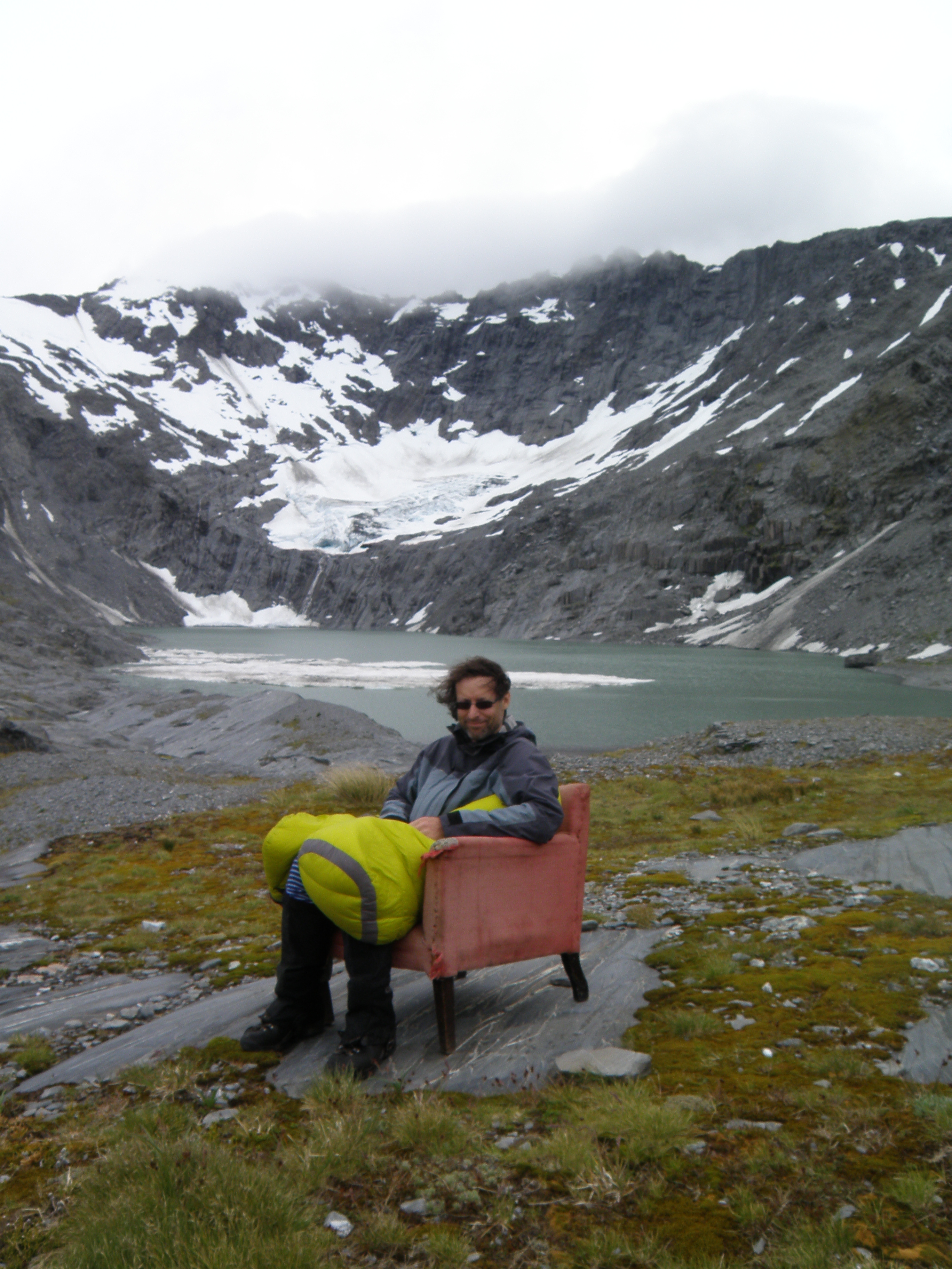
Bordered by a round basin, Ivory Lake is decorated by flotillas of ice bergs that shine like pearls. At the lake’s head sits the messy remnants of the Ivory Glacier – ice sheets stacked like a bunch of rotting cardboard files. Ivory Lake Hut sits back from the lake on the ice smoothed rock lip of the cirque, a pale shade of cream with a faded red roof. The hut was built by the Ministry of Works in the 1960’s to monitor glacier dynamics. The data collected is used to understand the climate change impacts on water storage. Hardly anyone visits these days and most visitors come by chopper so we were surprised to read that another tramping party of two had stayed the previous night and we’d missed them by a few hours.
Park Dome day
It’s fine again but the persistent wind is insufficient to chase away the high cloud. Mike climbs Park Dome (2304m) anyway. DJ and I enjoy the superb views back down to the lake from part way up then retreat so DJ can rest his knees. It’s great to relax and soak up the specialness of this spot and imagine what it was like in its heyday. The workshop attached to the hut has a collection of rusty old tools. There is an extensive range of magazines from the 1970s. As well as the usual National Geographics, Readers Digests, Forest and Birds and FMC Bulletins there are Time Magazines, a Cleo and even a battered Playboy. What will happen to Richard Nixon? Will the Shar survive in Iran? All of the old hut books remain on site although it is hard to read the earlier pencilled entries. I spot comments from several WTMC parties. We give the hut arm chair an airing beside the lake. There used to be a hut boat but sadly it’s been removed. I go for a stroll to admire the vast array of wild flowers and mosses in the fragile alpine mini meadows and inspect the battered collection of preserved insects in the cupboard.
Beaumont day
It’s New Years’ Eve and we have 13km to travel to Prices Hut in the Whitcombe Valley. In bright sunshine and lovely clear, windless conditions we cross the lake outlet and head up onto the tops. Travel is easy as we stick to a broad ridge between the Ivory glacier and Sawtooth ridge which leads to the Tusk (2046m). Occasionally we skirt around particularly exposed sections of ridge but in some places we have to take the gnarly route. We don our crampons for snow then remove them again for the flaky rock, some of which stands up to attention like hair that has been gelled then backcombed. We reach our high point, Mt Beaumont (2118m) late morning and detour to West Beaumont (2136m). When the clag lifts we have views across to Mt Tasman and Mt Cook to the south and the coast in the west.


Early afternoon we scramble over the Rotunda (2084m) ending the long, hot pleasant wander along our broad ridge at altitude 2000m. We enjoy a gentle descent along Steadman Brow, where tarns enable us to replenish our water supplies. A huge cairn on Cropp Knob (1508m) marks the turnoff to the DoC track that drops directly into the Whitcombe Valley. Initially we follow faint animal trails down a scrub covered, knife-edge ridge. Looking at the steep scree slopes either side I’m glad I still have my helmet on. After an excruciating hour or so we drop into the shade of the bush where hand holds were more plentiful and rest stops feasible. After another hour or two of painstaking, knee breaking descent we reach Price’s Flat footbridge. From here we cross the Whitcombe and head up past the old hut to Prices Hut. While the afternoon had been tedious and tiring, today was a highlight. Travelling on the tops in fine conditions trumps grovelling round in a valley any day. We were all asleep long before 2012 rolls round.
Whitcombe Days
It took the pair who pioneered the route over Whitcombe Pass to the coast 14 days. They were plagued by rough travel, rain, cold, lack of food and sandflies. Whitcombe promptly drowned trying to cross the flooded Taramakau. We have it easy in comparison. A cloudless sky and a scorching sun means our biggest challenge is avoiding sunstroke plus the occasional slip and waterfall where the track has washed away necessitating a few high traverses to avoid Whitcombe Gorge. We still all manage a few spills and souvenir a few scratches and bruises to add to our collections.
We probably have it easy compared to kayakers as well. The milky blue water cascading over marbled grey rock worn smooth is home to some mean looking white water. The Whitcombe is popular with white water kayakers and while they tend to chopper in the complexity of the rapids mean that unless you have incredible skills or a death wish quite a bit of portage is required. Turning the pages of the Prices Flat hut book you can almost smell the adrenalin fuelled bravado.
At lunchtime we rest in the shade of Frew hut. Time seems to stand still as we wander slowly beside the river absorbing the heat coming off the river boulders, secure in the knowledge we don’t have far to go and there was no point in hurrying. Mike looks for gold. Now on a well patronised tramping circuit we meet a couple of trampers heading in for a long trip and a couple of local hunters.
Rapid Falls hut is so hot we have to open the door and windows then wait outside till the biting sandflies convince us entering is the better option. Getting to sleep is difficult amongst the ominous buzz of mosquitos. There is nothing reformed about the Rapid Falls hut weka, he has an extensive collection of possessions!

As it began it ends with mist rising off the Whitcombe, and the mighty Hokitika River. The air is heavy and warm. Our packs are light and we are still sweating. Three hot, grubby trampers slap at sandflies while doing a final lap of boulder hopping to reach a four-wheel drive track over farmland. Then it’s out to a minor road to wait with the cows. One thing has changed. We will not be walking all the way to Hokitika.
